


By Richard Dunn
Hurricane Sandy was the deadliest and most destructive hurricane of the 2012 Atlantic hurricane season, as well as the second-costliest hurricane in United States history. Hurricane Sandy was also the largest Atlantic hurricane ever recorded (as measured by diameter with winds spanning 1,100 miles (1,800 km)). The severe and widespread damage the storm caused in the United States, as well as its unusual merge with a frontal system, resulted in the nicknaming of the hurricane by the media and several organizations of the U.S. government “Super-storm Sandy”. I believe that there are too many unusual occurrences and coincidences for me to accept that this storm was a natural creation. Please use website links and navigation panels (particularly list and media) while reading for further information. The list sub section will provide a dot point listing of all Hurricane Sandy unusual occurrences and coincidences, all are sourced.
http://en.wikipedia.org/wiki/Hurricane_Sandy
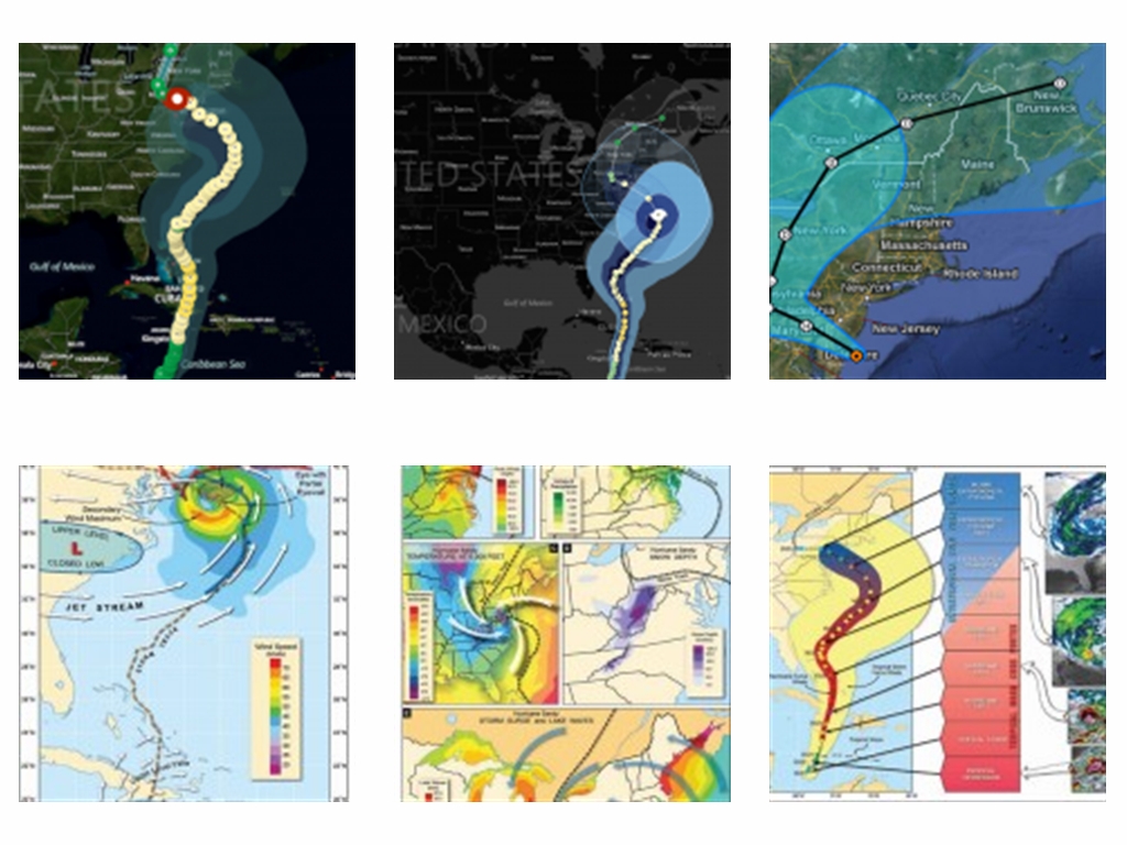
Sandy developed from a tropical wave in the western Caribbean Sea on October 22, quickly strengthened, and was upgraded to Tropical Storm Sandy six hours later. As the storm reached the North American coastline, the storm begins to curve with the coastline of North Carolina, South Carolina and Florida, rather than following a direct path (Refer to images provided). The storm then changes direction and heads west towards New Jersey and Philadelphia. While curving west towards New Jersey, the storm accelerated to a forward motion of nearly 30mph (The hybridization of Sandy – Atmos News (by Bob Henson)). When the storm reached Philadelphia it made a ninety degree turn (rather than going inland), heading through the western parts of New York and then up the east coast through Ottawa, Montreal, Quebec and New Brunswick. The storm lasted for a period of five days, hitting the most populated area of the east coast. Coincidentally, it also seems to circle the business capital of the United States, New York. Circling New York is the same as hitting it head on and if the United States was the subject of an attack, New York would be one of the primary targets (note September 11, 2001).

Hurricane Sandy’s devastating storm track is a rare one among hurricanes. The track of the storm — which took an unusual left-hand turn in the Atlantic before slamming into the East Coast — has an average probability of happening only once every 700 years. “The particular shape of Sandy’s trajectory is very peculiar, and that’s very rare, on the order of once every 700 years,” said Timothy Hall, a senior scientist at the NASA Goddard Institute for Space Studies who co-authored the study. That means that in any particular year, the chance of such a storm track happening is 0.0014 percent (Refer to NASA Simulation – Media). Source – Hurricane Sandy Was 1-in-700-Year Event: http://news.yahoo.com/hurricane-sandy-1-700-event-182934012.html
No other Atlantic hurricane of equal or greater strength has hit land at an angle anywhere near as perpendicular as Sandy, whose path was off by just 17 degrees from making a right angle with the coast. – http://blogs.agu.org/geospace/2013/06/03/hurricane-sandy-took-highly-unusual-path-but-climate-change-doesnt-get-the-blame-yet/
“Sandy’s track was the most perpendicular to the Atlantic Coast of any storm on record”. – http://news.nationalgeographic.com/news/2013/09/130902-hurricanes-climate-change-superstorm-sandy-global-warming-storms-science-weather/
In elementary geometry, the word perpendicular describes the relationship between two geometric objects that meet at a right angle.
An article by Amy Ellis Nutt and Stephen Stirling states: http://www.nj.com/news/index.ssf/2012/11/experts_argue_global_warmings.html
“It wasn’t supposed to happen. That’s what the weather experts kept saying immediately before, during and after Sandy smacked New Jersey in the face. Not this far north, they said, not in autumn, and certainly not this bad.“
An article by Dr. Jeff Masters states (Weather Underground): http://www.wunderground.com/blog/JeffMasters/comment.html?entrynum=2283
“We’re used to seeing hurricane-battered beaches and flooded cities in Florida, North Carolina, and the Gulf Coast. But to see these images from the Jersey Shore and New York City in the wake of Hurricane Sandy is a shocking experience. New Jersey only rarely gets hit by hurricanes because it lies in a portion of the coast that doesn’t stick out much, and is too far north. How did this happen? How was a hurricane able to move from southeast to northwest at landfall, so far north, and so late in hurricane season? We expect hurricanes to move from east to west in the tropics, where the prevailing trade winds blow that direction. But the prevailing wind direction reverses at mid-latitudes, flowing predominately west-to-east, due to the spin of the Earth. Hurricanes that penetrate to about Florida’s latitude usually get caught up in these westerly winds, and are whisked northeastwards, out to sea.”
Hurricane Sandy and the Climate Connection also confirms what Dr Jeff Masters states in the previous source (Skeptical Science): http://www.skepticalscience.com/hurricane-sandy-climate-connection.html
“Hurricane Sandy was an unprecedented storm in modern times, arriving late in the hurricane season, making landfall abnormally far to the north on the US east coast.”
You would think that the largest Atlantic hurricane ever recorded would hit in peak period? How did it get so far north?
An article by Spencer Platt states: http://realtruth.org/articles/121027-001.html
“Normally, when hurricanes approach the East Coast from Sandy’s angle, they are pulled safely out to sea by a semi-permanent low-pressure center near Iceland. This time around, that low pressure isn’t there. In fact, it’s been replaced by a high pressure so intense it only occurs approximately 0.2% of the time on average. The coincidence of that strong of a high pressure ‘block’ being in place just when a hurricane is passing by—in and of itself a very rare occurrence—is just mind bogglingly rare. It’s the kind of stuff that’s important enough to rewrite meteorological textbooks. The result, instead of heading out to sea Sandy’s full force will be turned back against the grain and directed squarely at the East Coast.”
Sandy also had the biggest storm surge ever seen.
Sandy lives up to the hype (Live Science): http://www.livescience.com/24433-hurricane-sandy-predictions.html
“The 13-foot (3.9 meters) waves at the Battery Park in lower Manhattan crushed the 1821 record for storm-surge height there. In the days before the storm, the National Weather Service predicted record surges and flooding in the New York and New Jersey region, with peak levels of 11 to 13 feet (3 to 4 m) at the Battery.”
The record storm surge can be explained by the following factors.
Risks of Hurricane Sandy-like Surge Events Rising (Climate Central): http://www.climatecentral.org/news/hurricane-sandy-unprecedented-in-historical-record-study-says-15505
“The impact angle of Hurricane Sandy was its most unusual feature, ensuring the storm surge would case maximum damage, Hall said. The storm’s left-hand turn put the most dangerous right-front quadrant on top of New Jersey and southeastern New York, pummeling these areas with an historic storm surge and record high waves. That, combined with astronomical high tides, led to record storm tide levels.”
Also, Sandy made landfall just when a full moon was brightening the sky. The moons gravity pulls on earths water, fractionally lifting the surface towards itself. Oceans bulge towards the moon to generate two oceanic tides per day. During a full moon, the moons gravity can align with that of the sun to produce particularly high tides. The full moon during the storm put an extra 6 feet onto the sea level, which was another contributing factor to the record storm surge. If Hurricane Sandy was an attack on the east coast of the United States, whoever was responsible picked the perfect time to attack.
On October 25th, the National Weather Service accurately predicted Hurricane Sandy would make landfall in southeastern New Jersey four days prior to actually making landfall. This is the same day that Hurricane Sandy was dubbed “Frankenstorm” by NOAA (National Oceanic and Atmospheric Administration). If you remember the story of “Frankenstein”, Frankenstein was put together with different body parts and struck by lightning to give him life. Frankenstein was manufactured. If Hurricane Sandy was labeled Frankenstorm, maybe Sandy was manufactured also? Is this the correlation between Frankenstein and Frankenstorm? Conspiracy or coincidence? It is also very coincidental that Hurricane Sandy was dubbed Frankenstorm the same day the National Weather Service predicted the storm would make landfall in New Jersey. Apparently, the European weather models were very accurate in predicting what Hurricane Sandy would do ahead of time. How accurate were the models exactly? Hurricane Sandy sped up just before New Jersey (as sourced earlier in the post), just before the major catastrophe of the storm. Did they predict that Sandy would speed up just before New Jersey?
There are so many aspects of Sandy that coincide with landfall.
- Sea level pressure hits peak just as Sandy makes landfall, 952hPa.
- Surface wind speed hits peak just as Sandy makes landfall, 92mph.
- Sandy speeds up just before landfall.
- No other Atlantic hurricane of equal or greater strength has hit land at an angle anywhere near as perpendicular as Sandy.
- Sandy made landfall when a full moon was brightening the sky.
- Sandy had the biggest storm surge ever seen.
Was the National Weather Service aware that so many aspects of the storm would coincide with landfall when they predicted Hurricane Sandy would make landfall in New Jersey and when Hurricane Sandy was labeled “Frankenstorm”, four days prior to making landfall?
Is this a freak set of unusual occurrences and coincidences, or was Hurricane Sandy an attack on the east coast of the United States?
Please refer to the “list” sub section of this website for a list and explanation on all Hurricane Sandy unusual occurrences and coincidences. To watch a simulation of Hurricane Sandy by NASA refer to the “media” sub section of this website.
Image Source – Hurricane Sandy: The Science and Impacts of a Superstorm – http://www.weatherwise.org/Archives/Back%20Issues/2013/March-April%202013/hurricane-sandy-full.html
(Click on picture to enlarge)
After looking at Sandy, I focused my attention on searching for weather anomalies by looking through historical storm data over the last 10 years.
On March 28th 2004 the “Nameless Hurricane” (also known as Cyclone Catarina) crashed into the coast of Brazil. The storm damaged around 40,000 homes and destroyed 1500; 40% of the rice crop were also lost. Total damages were estimated at $400 million USD. It also killed at least three and injured at least 75. At least 2,000 people were left homeless following the storm.
NASA Science: “The Nameless Hurricane” – http://science.nasa.gov/science-news/science-at-nasa/2004/02apr_hurricane/
Cyclone Catarina was the first-ever hurricane formed in the South Atlantic. Meteorologists were left scratching their heads in bewilderment as the familiar swirl of clouds, complete with a well-defined eye, appeared in an oceanic basin where none had been spotted before. NASA hurricane researcher Robbie Hood stated that “this really caught everybody off guard, hurricanes aren’t supposed to be in that part of the world”.
Typically, tropical cyclones do not form in the South Atlantic Ocean, due to strong upper level shear, cool water temperatures, and the lack of a convergence zone of convection. While Catarina formed in an unusual area, its relation to global warming or any other type of global climatic change is still up for debate. The Brazilian Society of Meteorology attributed it to “climatic changes and atmospheric anomalies”, while other researchers have indicated that it could be the result of the Southern Annular Mode or other seasonal variations in weather within the Southern Hemisphere, again linked to global changes in climate. However, more research in the area is still needed to make a conclusion. Hurricanes are never spotted in this part of the world. Have researchers considered Cyclone Catarina to be the result of weather modification?
http://en.wikipedia.org/wiki/Cyclone_Catarina
The image below is the path of Cyclone Catarina. Note that the path of Catarina is also unusual.

The 2005 Atlantic hurricane season was another recent unusual weather event that should be noted, as it was the most active Atlantic hurricane season in recorded history, shattering numerous records and was also the year that Hurricane Katrina hit Louisiana, the most deadliest Hurricane to hit the United States since 1928, resulting in the death of 1833 people. There were 28 named storms in the 2005 Atlantic hurricane season (storms with sustained winds of at least 39 miles per hour). In addition, there were an unprecedented 14 hurricanes, of which seven were major hurricanes (Category 3 or better on the Saffir-Simpson Scale). Three category 5 storms (sustained winds of 156 miles per hour or more) formed in the Atlantic Basin for the first time in a single season (Katrina, Rita, and Wilma). Four major hurricanes and three tropical storms made landfall in the United States, with an eighth storm (Ophelia) brushing the North Carolina coast.
http://en.wikipedia.org/wiki/2005_Atlantic_hurricane_season
Note the National Hurricane Center (NHC) predictions versus the actual number of storms for each hurricane season from 2002-2012 on the image below. Pay special attention to the 2005 season (11-15 storms predicted, 28 storms in total).
http://www.theguardian.com/world/2013/sep/13/hurricane-season-inaccurate-forecasts

Weather warfare is the use of weather control techniques for military purposes. As a quick introduction to the website and an introduction to weather warfare in general, I would like to provide readers a documentary to watch by the History Channel, That’s Impossible – Episode #3, Weather Warfare. The documentary explains that the power to use tornado’s, hurricanes and the deadliest weather as weapons of war may now be possible. The documentary investigates reports that weather weapons are in development and reveal the technology that, in the future, could turn hurricanes, earthquakes and even tsunamis into some of the most powerful and plausibly deniable weapons of mass destruction the world has ever seen.
Weather Warfare Documentary (History Channel)
TLB reccomends you visit WEATHER WAREFARE for more great/pertinent articles and information.
See featured article here: http://weatherwarfare.worldatwar.info/2012/11/hurricanesandy/
Leave a Reply