


The Makran Coast Where the US Is Most Likely to Land in Iran
Chabahar Bay–Konarak the most rational and militarily coherent options for an imperial‑style invasion.
By Freddie Ponton | G;obal Affairs via 21WIRE
This report is not a neutral wargame. Look at it as a forensic analysis of a war that is already illegal, already underway, and already being shaped by the kind of desperation that only great empires show when they feel their grip on the world slipping. The US‑led bombing campaign against Iran, carried out in tandem with Israel, is not a defensive or “limited” operation; it is the opening gambit in a broader project to re‑establish direct control over the Gulf, to break Iran’s regional autonomy, and to shore up the petrodollar system that keeps the US dollar on life support and permits the empire to keep racking up debts it has no intention of ever honestly repaying.
Within this framework, we approach the escalating conflict through a deliberately pragmatic and operational lens, breaking down the most rational and militarily coherent options for an imperial‑style invasion. We aim to show that Chabahar Bay–Konarak in southeastern Iran points to the only landing vector that actually aligns with Washington’s and Tel Aviv’s combined objectives, which are to cut Tehran off from the Indian Ocean, to exploit its ethnic peripheries, and to re‑entrench Western dominance in the world’s most contested energy corridor.
Yet being pragmatic does not mean being complicit. On the contrary, this report uses the West’s own logic, its doctrine, its deployments, its planning culture, against it, exposing not only how the war is being planned, but also how it exposes the deepening fragility of US hegemony and the naked expansionist ambitions of Israel, all while a petrodollar‑centred financial order props up an empire that can no longer afford to lose.
By the time you reach the final lines, it will be clear that this is more than a prediction of a possible amphibious landing; it is an indictment of a war machine that has run out of rational, lawful options and is now resorting to wars of choice, proxy destabilisation, and systematic attacks on a sovereign state to buy more time for a system that is already mortally indebted, in every sense of the word.
The Architectures of Invasion
Western coverage has strained to present the current US–Israeli onslaught on Iran as a calibrated “air and missile campaign,” a punitive operation meant to “restore deterrence” rather than pave the way for a ground war. That framing collapses as soon as you look at the target set and force posture. In the opening days of Operation Epic Fury, US officials boasted of hitting more than 1,250 targets across Iran, including command nodes, air defenses, missile facilities and naval bases; satellite imagery showed burning ships and destroyed infrastructure at Bandar Abbas, Konarak and other key ports. This is not calibrated signalling. Look at it as the classic prelude to stripping a state of its ability to contest sea and air in two critical theatres at once: the Strait of Hormuz and the Gulf of Oman.

IMAGE: Satellite imagery from Planet Labs shows damage at Konarak naval base in southern Iran, left, and Iran’s Bandar Abbas naval headquarters in the Persian Gulf, right. (Source: Planet Labs PBC)
In the months before the war, Marines from the 11th Marine Expeditionary Unit rehearsed exactly the kind of operations such a campaign would require, conducting large‑scale Realistic Urban Training exercises in arid, coastal and desert terrain that closely resembles the low‑hilled, sparsely vegetated landscapes of southeastern Iran. Those drills, officially billed as preparation for “littoral operations in contested environments,” look very different once you place them alongside the current deployment of the same unit toward the Gulf of Oman.
VIDEO: 11th MEU Marines Conduct High-Intensity Raid During Realistic Urban Exercise (Nov. 2025) (Source: U.S. Military One)
At the same time, Washington has moved in exactly the assets you would need for something much more than a bombardment. In March 2026, Pentagon officials confirmed that the USS Boxer (LHD‑4), an amphibious assault ship carrying roughly 2,500 Marines from the 11th Marine Expeditionary Unit, was heading into the region with an Amphibious Ready Group.
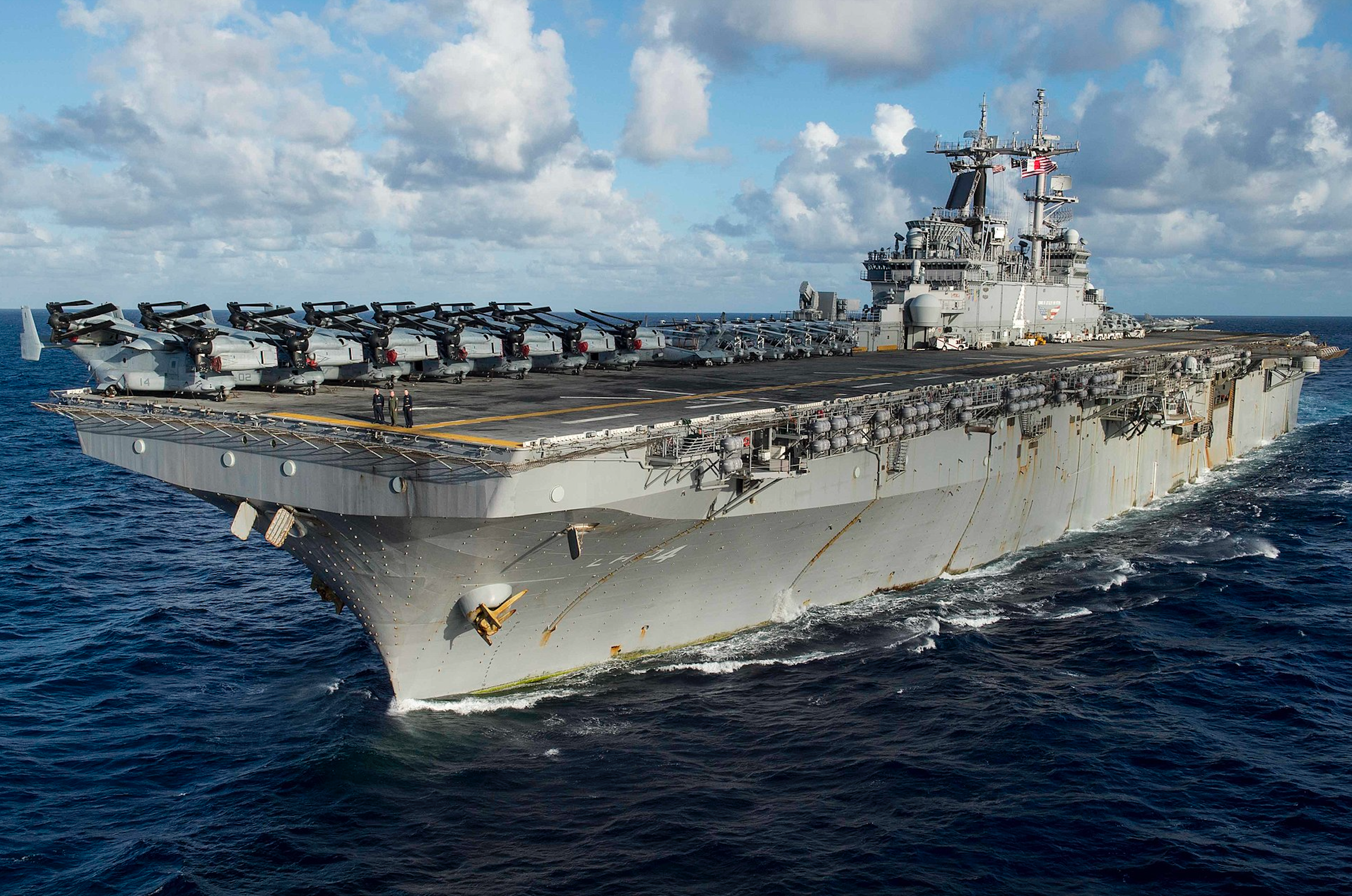
IMAGE: USS Boxer (LHD-4) underway in the Pacific Ocean (Source: US Navy)
In addition, the US is deploying a second amphibious force, the Tripoli Amphibious Ready Group (ARG), built around the America‑class amphibious assault ship USS Tripoli (LHA‑7), which is carrying the 31st Marine Expeditionary Unit (MEU) from its forward base in Sasebo, Japan. Together, the Boxer ARG with the 11th MEU and the Tripoli ARG with the 31st MEU form a redundant amphibious stack in the Gulf, far exceeding the force needed for symbolic raids and consistent with the planning requirements of a larger, sustained campaign.
Yet if Washington imagines that it is the only rational actor in this theatre, it has already misunderstood the war. Tehran has spent four decades building a layered, asymmetric shield around every inch of its coastline, and every ship that enters the Gulf enters a calculated risk that Tehran is ready to turn into a regional reckoning rather than a “controlled” landing.
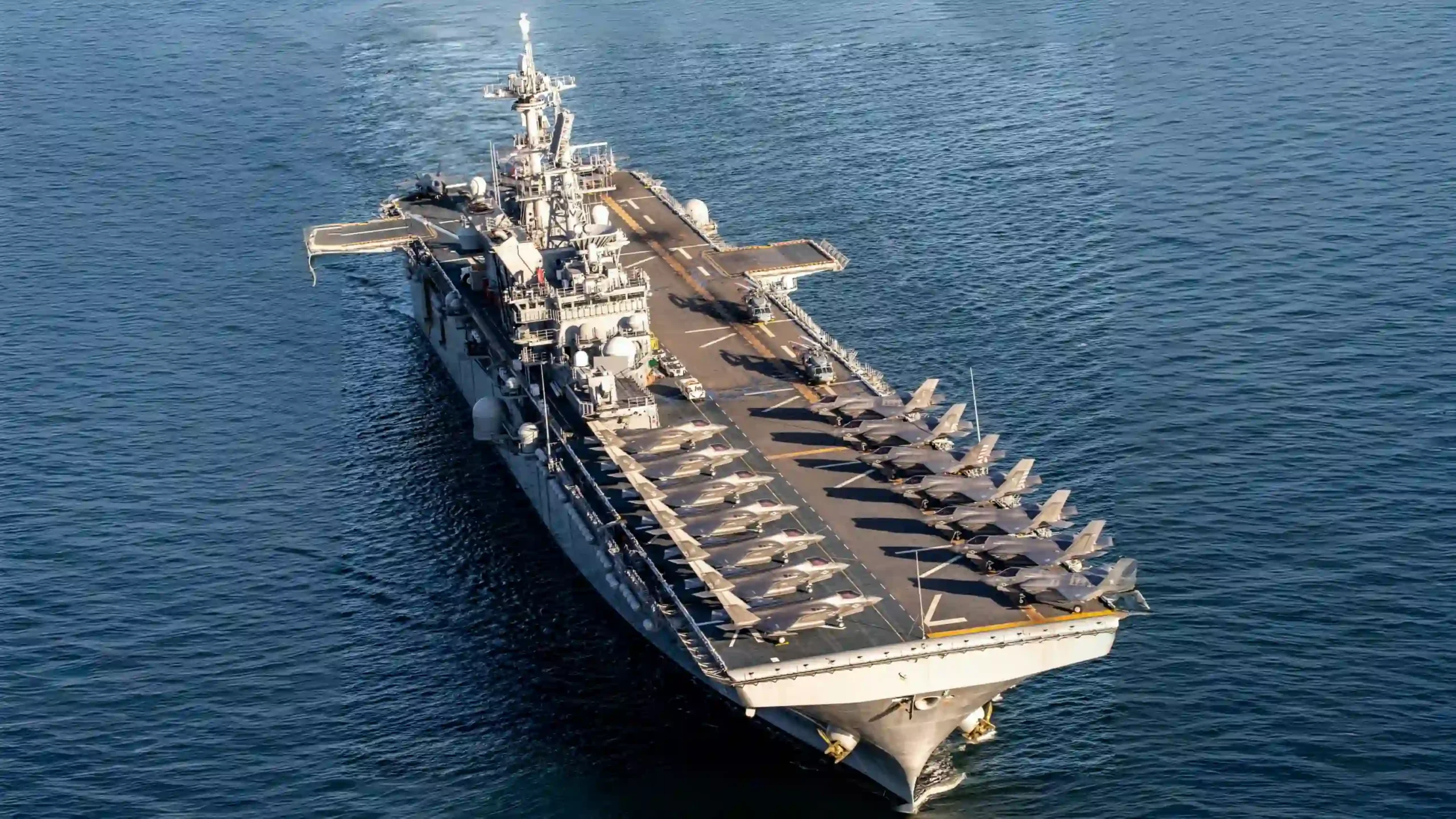
IMAGE: The U.S. Navy’s amphibious assault ship USS Tripoli (LHA-7) (Source: U.S. Navy)
US‑aligned media and countless YouTube channels have begun rehearsing amphibious options in public, fixating on a possible seizure of Kharg Island, the small oil-export hub in the northern Gulf. That fixation keeps debate locked on spectacular “oil‑island” scenarios that are politically explosive and tactically dubious, and away from a more coherent plan that fits the actual strike pattern.
This article does not claim insider knowledge of a signed invasion order. It is a red‑team analysis of what a rational US planner would do with the forces, doctrine and target sets already on display. If you map the opening waves of Epic Fury, a different picture emerges. One that reminds us that what we are witnessing is not a defensive war waged by a beleaguered state, but an illegal, imperial‑style campaign designed to break Iran’s regional autonomy and dictate its fate from the outside.
The coalition has systematically attacked naval command and logistics hubs at both ends of Iran’s southern maritime architecture. To the west, it struck Bandar Abbas naval base, Iran’s main naval base at the mouth of the Strait of Hormuz, causing extensive fires and damage to the forward base ship Makran and several surface combatants.
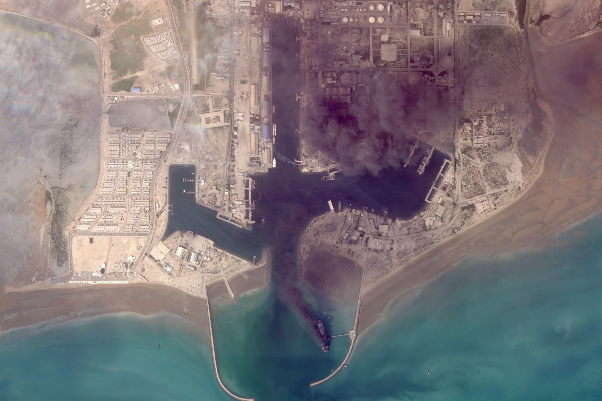
IMAGE: This satellite image from Planet Labs PBC shows fires burning on ships after a US military attack on a port in Bandar Abbas, Iran, March 2, 2026. (Source: Planet Labs PBC via AP)
To the east, it hammered Konarak Naval Base and the IRGC Navy’s Imam Ali base at Chabahar, along with co‑located drone and airfields at Konarak International Airport. Chabahar serves as a vital commercial and naval center located on the Gulf of Oman. Its strategic significance is heightened by its closeness to Pakistan’s Gwadar port and its involvement in regional trade routes, such as the International North-South Transport Corridor (INSTC), India’s Gateway to Central Asia. Major operational analyses describe Konarak as the headquarters of Iran’s Third Naval District, responsible for the Gulf of Oman, and Chabahar as Iran’s only deep‑water port with direct Indian Ocean access. A preliminary field report adds that strikes hit the Konarak air base used by the Navy and IRGC Aerospace Forces, damaging two drone units that had recently attempted to fly an armed Shahed‑129 near the carrier Lincoln. Iran’s military announced that it targeted the USS Abraham Lincoln aircraft carrier using coastal cruise missiles, as reported by state media. The US has neither confirmed nor denied these claims. Meanwhile, at Chabahar’s Imam Ali base, a Jamaran/Moudge‑class frigate was sunk at its moorings.
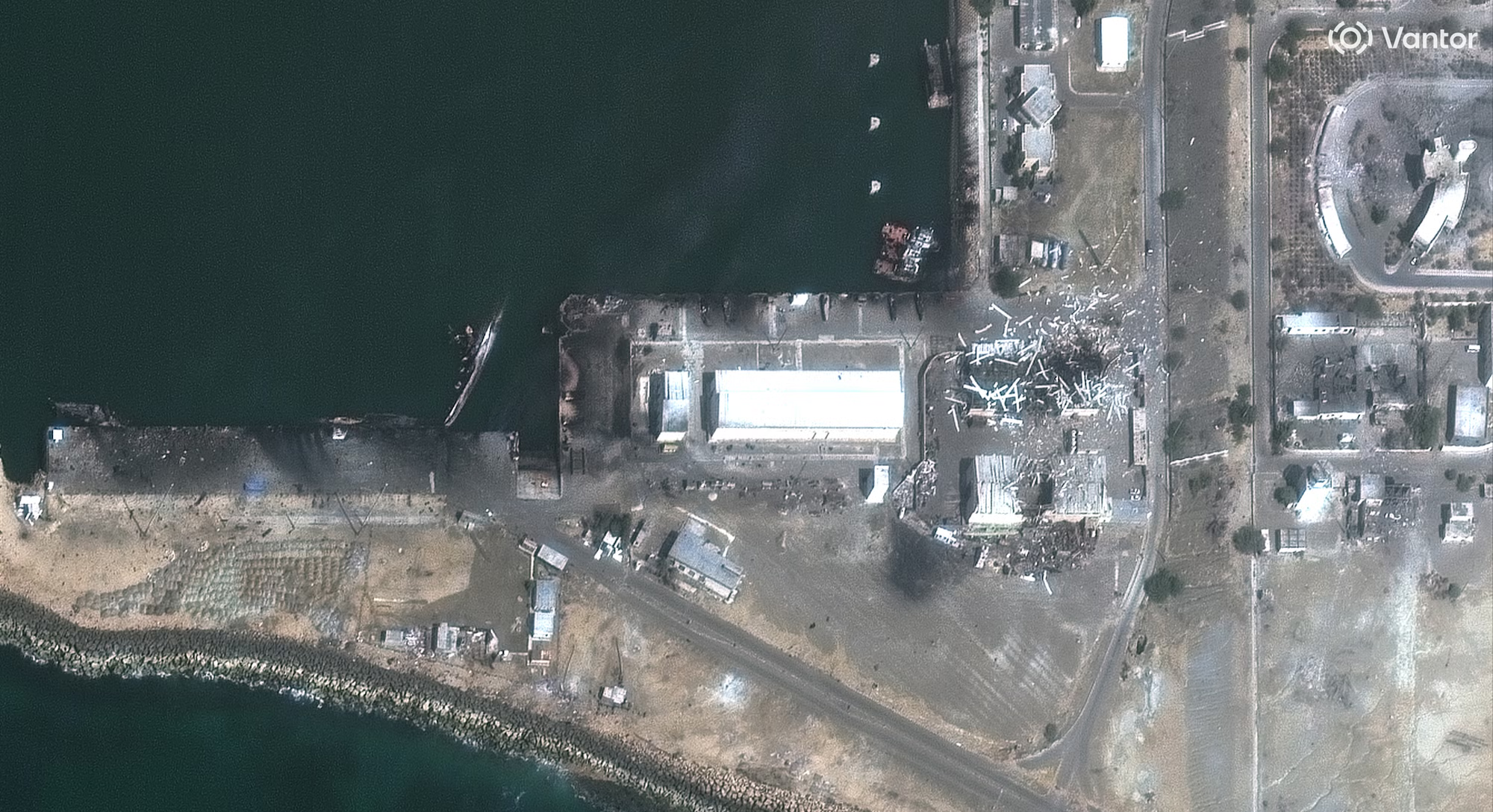
IMAGE: Destroyed and sinking vessels and damaged buildings at a naval base in Konarak. (Source: Satellite image ©2026 Vantor)
In other words, the US‑Israeli coalition has already done what any war college manual would prescribe before contemplating amphibious operations on Iran’s southern coast. They have destroyed the ships, damaged airfields and shot down drones that could contest sea control from Bandar Abbas to Konarak and Chabahar. Today, despite the fog of war and exaggerated claims, the question is no longer whether a ground option exists, but where it would make the most sense to land.
Anatomy of a Landing: Kharg, Qeshm and the Makran Alternative
On a map, Kharg Island and Qeshm Island are tempting. Kharg is small and isolated. Qeshm squats like a gatekeeper in the Strait of Hormuz. In the Anglo‑American imagination, both lend themselves to cartoonish “seize the island, win the war” narratives. A serious operational analysis, however, shows that both are built to Iran’s strengths, not to US needs.
Kharg is first and foremost an oil island. For decades, it has handled a large share of Iran’s crude exports, with some naval commentators noting that up to 90 % of export capacity has at times been routed through its terminal infrastructure. That is precisely why it has long sat on Western strike lists, and why Tehran has rushed to harden it. In March 2026, regional reporting citing Western intelligence sources made clear that Iran had reinforced Kharg’s defenses, adding troops, strengthening air defenses and mining key landing zones in anticipation of a US attempt to seize the island. To land Marines on Kharg now would mean sending them onto a mined beach under short‑range missile, drone and artillery fire, at the precise point most likely to detonate a global oil shock. It is the kind of move an administration sells to television, not a planner’s idea of a clean entry point.
Qeshm, meanwhile, is the heart of Iran’s asymmetric maritime doctrine. A detailed feature described the island as an “underground missile fortress” and “missile city” of tunnels, hidden launchers, fast‑attack boats and coastal artillery, built to saturate Hormuz with anti‑ship fire and swarm attacks. Other assessments underline that the IRGC Navy has spent years building up hundreds of fast boats, missile‑armed Ashura‑class craft and high‑speed attack vessels, many of them based along this belt, supported by new Shahid Soleimani‑class corvettes. Even after Epic Fury, one of those Soleimani‑class ships had to be hunted down and sunk near Hormuz, proof that meaningful capability survived there. Any attempt to storm Qeshm would mean attacking into the densest remaining cluster of Iran’s swarm and missile assets, through the narrowest sea lanes, under global scrutiny.

IMAGE: IRGC Navy fast boats patrolling the Strait of Hormuz (Source: US Naval Institute)
Against that backdrop, the Chabahar–Konarak sector on the Makran coast looks very different. Geographically, it faces the wide Gulf of Oman, and not the cramped interior of the Persian Gulf, which mean in principal, there is more room for US carrier groups and amphibious ships to manoeuvre, more distance from the heaviest missile and fast‑boat concentrations that ring Hormuz, and a broader set of approaches that cannot all be mined or monitored as easily as the Strait. The Konarak naval complex controls the Third Naval District, which covers this Gulf of Oman flank. That is why Epic Fury hit it so hard, destroying warships at their piers and smashing the co‑located air and drone bases, while also striking the IRGC Navy’s Imam Ali base at Chabahar until satellite images showed multiple vessels sunk at their moorings.
Iran has also signalled, perhaps unintentionally, that it sees this region as a future littoral battlespace. In February 2025, the Zulfiqar 1403 joint drill staged a combined amphibious operation in the Third Naval Region near Konarak, involving Navy commandos, the Tonb amphibious vessel and Karrar tanks and BMP‑2s in a five‑stage sequence culminating in a “beaching” manoeuvre to secure a shorehead and deploy forces onto “enemy territory.” That exercise, and the wider doctrine that orders the IRGC Navy to expand into the “Sea of Makran” and the northern Arabian Sea, confirms that Tehran now treats Makran as a front line, and not as a backwater.
If the US believes it is studying Iran’s “doctrine,” Iran has already been studying the US’s playbook for decades—the same tactics of saturation, asymmetry, and regional bleed‑out that have gutted Western forces elsewhere will be re‑engineered for the Gulf of Oman. Any amphibious foothold will be treated less as a victory and more as a trigger for a wider confrontation.
At the same time, Washington has moved in exactly the assets you would need for something much more than a bombardment. In March 2026, Pentagon officials confirmed that the USS Boxer (LHD‑4), an amphibious assault ship carrying roughly 2,500 Marines from the 11th Marine Expeditionary Unit, was heading into the region with an Amphibious Ready Group.
In addition, the US is deploying a second amphibious force, the Tripoli Amphibious Ready Group (ARG), built around the America‑class amphibious assault ship USS Tripoli (LHA‑7), which is carrying the 31st Marine Expeditionary Unit (MEU) from its forward base in Sasebo, Japan. Together, the Boxer ARG with the 11th MEU and the Tripoli ARG with the 31st MEU form a redundant amphibious stack in the Gulf, far exceeding the force needed for symbolic raids and consistent with the planning requirements of a larger, sustained campaign.
Yet if Washington imagines that it is the only rational actor in this theatre, it has already misunderstood the war. Tehran has spent four decades building a layered, asymmetric shield around every inch of its coastline, and every ship that enters the Gulf enters a calculated risk that Tehran is ready to turn into a regional reckoning rather than a “controlled” landing.
US‑aligned media and countless YouTube channels have begun rehearsing amphibious options in public, fixating on a possible seizure of Kharg Island, the small oil-export hub in the northern Gulf. That fixation keeps debate locked on spectacular “oil‑island” scenarios that are politically explosive and tactically dubious, and away from a more coherent plan that fits the actual strike pattern.
This article does not claim insider knowledge of a signed invasion order. It is a red‑team analysis of what a rational US planner would do with the forces, doctrine and target sets already on display. If you map the opening waves of Epic Fury, a different picture emerges. One that reminds us that what we are witnessing is not a defensive war waged by a beleaguered state, but an illegal, imperial‑style campaign designed to break Iran’s regional autonomy and dictate its fate from the outside.
The coalition has systematically attacked naval command and logistics hubs at both ends of Iran’s southern maritime architecture. To the west, it struck Bandar Abbas naval base, Iran’s main naval base at the mouth of the Strait of Hormuz, causing extensive fires and damage to the forward base ship Makran and several surface combatants.
To the east, it hammered Konarak Naval Base and the IRGC Navy’s Imam Ali base at Chabahar, along with co‑located drone and airfields at Konarak International Airport. Chabahar serves as a vital commercial and naval center located on the Gulf of Oman. Its strategic significance is heightened by its closeness to Pakistan’s Gwadar port and its involvement in regional trade routes, such as the International North-South Transport Corridor (INSTC), India’s Gateway to Central Asia. Major operational analyses describe Konarak as the headquarters of Iran’s Third Naval District, responsible for the Gulf of Oman, and Chabahar as Iran’s only deep‑water port with direct Indian Ocean access. A preliminary field report adds that strikes hit the Konarak air base used by the Navy and IRGC Aerospace Forces, damaging two drone units that had recently attempted to fly an armed Shahed‑129 near the carrier Lincoln. Iran’s military announced that it targeted the USS Abraham Lincoln aircraft carrier using coastal cruise missiles, as reported by state media. The US has neither confirmed nor denied these claims. Meanwhile, at Chabahar’s Imam Ali base, a Jamaran/Moudge‑class frigate was sunk at its moorings.
In other words, the US‑Israeli coalition has already done what any war college manual would prescribe before contemplating amphibious operations on Iran’s southern coast. They have destroyed the ships, damaged airfields and shot down drones that could contest sea control from Bandar Abbas to Konarak and Chabahar. Today, despite the fog of war and exaggerated claims, the question is no longer whether a ground option exists, but where it would make the most sense to land.
Anatomy of a Landing: Kharg, Qeshm and the Makran Alternative
On a map, Kharg Island and Qeshm Island are tempting. Kharg is small and isolated. Qeshm squats like a gatekeeper in the Strait of Hormuz. In the Anglo‑American imagination, both lend themselves to cartoonish “seize the island, win the war” narratives. A serious operational analysis, however, shows that both are built to Iran’s strengths, not to US needs.
Kharg is first and foremost an oil island. For decades, it has handled a large share of Iran’s crude exports, with some naval commentators noting that up to 90 % of export capacity has at times been routed through its terminal infrastructure. That is precisely why it has long sat on Western strike lists, and why Tehran has rushed to harden it. In March 2026, regional reporting citing Western intelligence sources made clear that Iran had reinforced Kharg’s defenses, adding troops, strengthening air defenses and mining key landing zones in anticipation of a US attempt to seize the island. To land Marines on Kharg now would mean sending them onto a mined beach under short‑range missile, drone and artillery fire, at the precise point most likely to detonate a global oil shock. It is the kind of move an administration sells to television, not a planner’s idea of a clean entry point.
Qeshm, meanwhile, is the heart of Iran’s asymmetric maritime doctrine. A detailed feature described the island as an “underground missile fortress” and “missile city” of tunnels, hidden launchers, fast‑attack boats and coastal artillery, built to saturate Hormuz with anti‑ship fire and swarm attacks. Other assessments underline that the IRGC Navy has spent years building up hundreds of fast boats, missile‑armed Ashura‑class craft and high‑speed attack vessels, many of them based along this belt, supported by new Shahid Soleimani‑class corvettes. Even after Epic Fury, one of those Soleimani‑class ships had to be hunted down and sunk near Hormuz, proof that meaningful capability survived there. Any attempt to storm Qeshm would mean attacking into the densest remaining cluster of Iran’s swarm and missile assets, through the narrowest sea lanes, under global scrutiny.
Against that backdrop, the Chabahar–Konarak sector on the Makran coast looks very different. Geographically, it faces the wide Gulf of Oman, and not the cramped interior of the Persian Gulf, which mean in principal, there is more room for US carrier groups and amphibious ships to manoeuvre, more distance from the heaviest missile and fast‑boat concentrations that ring Hormuz, and a broader set of approaches that cannot all be mined or monitored as easily as the Strait. The Konarak naval complex controls the Third Naval District, which covers this Gulf of Oman flank. That is why Epic Fury hit it so hard, destroying warships at their piers and smashing the co‑located air and drone bases, while also striking the IRGC Navy’s Imam Ali base at Chabahar until satellite images showed multiple vessels sunk at their moorings.
Iran has also signalled, perhaps unintentionally, that it sees this region as a future littoral battlespace. In February 2025, the Zulfiqar 1403 joint drill staged a combined amphibious operation in the Third Naval Region near Konarak, involving Navy commandos, the Tonb amphibious vessel and Karrar tanks and BMP‑2s in a five‑stage sequence culminating in a “beaching” manoeuvre to secure a shorehead and deploy forces onto “enemy territory.” That exercise, and the wider doctrine that orders the IRGC Navy to expand into the “Sea of Makran” and the northern Arabian Sea, confirms that Tehran now treats Makran as a front line, and not as a backwater.
If the US believes it is studying Iran’s “doctrine,” Iran has already been studying the US’s playbook for decades—the same tactics of saturation, asymmetry, and regional bleed‑out that have gutted Western forces elsewhere will be re‑engineered for the Gulf of Oman. Any amphibious foothold will be treated less as a victory and more as a trigger for a wider confrontation.
[***]
From a US perspective, the pattern is clear. Kharg and Qeshm are obvious pressure points that Iran has turned into fortified traps. Chabahar–Konarak is the less-saturated but more strategically valuable flank, with its open water, an already degraded naval presence after Epic Fury, and direct access to the Makran coast that Tehran has spent a decade trying to turn into its escape route beyond Hormuz. That makes it the only plausible candidate for an amphibious landing that could change the shape of the war rather than produce sensational headlines.
Makran Under the Knife: Chabahar, Konarak and Iran’s Indian Ocean Pivot
The Makran coast, running from Chabahar toward the Pakistani border, has long been described in Iranian planning documents as a “lost paradise.” It is also central to Tehran’s attempt to break out of the geographic prison of the Persian Gulf. Official outlets and economic planners have tried to recast Makran as the core of a maritime‑oriented development strategy, in which Iran uses Chabahar Port as a deep‑water outlet to the Indian Ocean, bypasses the Strait of Hormuz and multiplies its land routes into Central and South Asia.
The numbers are not trivial. In 2024 and 2025, government decisions formalised a Makran development plan drawing on the National Development Fund to support major coastal projects, including the creation of 27 new coastal settlements and “new coastal spots,” about ten of them planned as cities in the Makran region, under the supervision of the Supreme Council of Urban Planning and Architecture. Former First Vice‑President Mohammad Mokhber called these “among the most important programs of the thirteenth government to activate the country’s maritime‑oriented economy.” The plan bundles ports, naval bases, logistics hubs and housing, with the Ports and Maritime Organisation reporting hundreds of millions of dollars in private investment already committed and hundreds of millions more being sought. Presidential statements repeatedly place Chabahar–Konarak at the centre of that vision.
This is exactly the infrastructure now being torn apart from the air. Epic Fury’s strikes on Konarak and Chabahar not only sink ships, but also hit the air base and drone facilities at Konarak International Airport, a key node for the regular Navy and IRGC Aerospace Forces, housing at least two drone units that had already been trying to shadow US carrier groups. They damaged or destroyed infrastructure at the IRGC Navy’s Imam Ali base in Chabahar, including a Jamaran‑class frigate. Other early‑war reports describe US jets targeting Iranian military positions near the Chabahar Free Trade Zone, with explosions heard behind the zone in Sistan‑and‑Baluchestan.
But Tehran did not build Makran, nor did it build the Chabahar Free Trade Zone to be a one‑sided US‑target corridor; it built it as a bridge to multipolarity, to diversify trade beyond the Strait of Hormuz and anchor Iran’s presence in the Indian Ocean. Every bomb that hits Chabahar or Konarak is not just a strike on a port, but an attack on a sovereign project of regional reintegration, and it will be foolish to ignore Tehran’s capability to respond in kind across the region, not just on this narrow coast
Western security think tanks have, in their own way, recognised how central this belt has become. A CSIS study of Iranian hybrid warfare points out that Iran has built bases and capabilities not just in the Persian Gulf and Strait of Hormuz, but also “in the Gulf of Oman outside the Gulf, and in Indian Ocean waters near the Strait,” using the Makran coast to extend its reach beyond Hormuz. A detailed Middle East Institute paper on the IRGC and the Persian Gulf region notes that Khamenei explicitly ordered the IRGC Navy to establish a permanent presence in the Indian Ocean, charging it with securing sea lanes in the Gulf of Oman and northern Arabian Sea.
Taken together, these strands show that Chabahar–Konarak sits at the core of Iran’s attempt to shift from a cornered “strait‑state” to a regional maritime actor. It shouldn’t be characterised as an expendable coastline, but rather as the bridge between Iran and the open Indian Ocean, already under concentrated attack by a coalition that is determined to inflict damage to Iran’s navy. If you were planning a ground incursion designed not just to punish but to break a state’s forward posture, you would not waste Marines on a mined oil island or a missile‑fortress chokepoint. You would cut at the Makran pivot.
Baluchistan: Proxy War Laboratory and Engine of Fragmentation
The military logic is only half the story. What makes Chabahar–Konarak uniquely dangerous for Tehran is that it is embedded in Sistan and Baluchestan Province, Iran’s largest and most volatile border region. Here, the Islamic Republic of Iran’s development schemes collide with deep ethnic, religious and economic fault lines that outside powers have studied and exploited for decades.
Declassified US intelligence already treated Baluchistan as a strategic hinge in 1980. The CIA’s “Baluchistan: A Primer” describes the region as a sparsely populated area of little economic importance but considerable strategic significance, noting its transnational Baluch population and history of rebellion. A later assessment by the US Central Intelligence Agency (CIA), “Pakistan’s Baluchistan: A Potential Trouble Spot”, warns of renewed instability if grievances are left unaddressed. Subsequent academic work, such as “The Baluch insurgency: linking Iran to Pakistan”, traces how militant groups in both states, including Sunni separatist groups such as Jundullah/Jaish al‑Adl, have used the porous border to stage attacks, while Iran has resorted to cross‑border raids and strikes in response.
This is not an old file gathering dust. In the last two years, Jaish al‑Adl has mounted high‑profile attacks across Sistan‑and‑Baluchestan, including a July 2025 gun‑and‑bomb assault on a courthouse in Zahedan that killed at least nine people and wounded 22, according to Iranian media and wire services. Gunmen infiltrated the court complex, opened fire on civilians outside and fought security forces for hours before being killed; the group later claimed responsibility. Earlier and subsequent attacks on police and IRGC positions prompted large‑scale counter‑terror sweeps, with the IRGC claiming to have killed 13 militants and arrested others. Profiles of Jaish al‑Adl list similar operations going back a decade, underscoring that this is a persistent insurgency, not a sporadic protest movement.
Iranian officials and state‑aligned outlets have characterised this insurgency as a foreign project by design. An IRGC commander quoted by Radio Farda accused the US and Saudi Arabia of supplying arms to Kurdish and Baluch groups, alleging that Riyadh had sent “three plane‑loads” of weapons and equipment to Jaish al‑Adl. A 2025 PressTV https://21stcenturywire.com/category/freddie-ponton/analysis portrays the group as a “terrorist organisation backed by CIA and Mossad,” claiming Iranian intelligence has traced funding and training back to Western and Israeli channels. However polemical these tensions may be, they show that Tehran understands Sistan‑and‑Baluchestan as a front in a proxy war, not simply a policing challenge.
For Tehran, this is not just a military calculation; it is a question of national survival, and of protecting a region historically exploited by foreign powers, from being turned into the frontline of a Western‑orchestrated proxy war.
Independent analysis of Iran’s internal structure reaches similar conclusions with different language. A 2026 piece on “Iran’s multiethnic structure and its geopolitical fault lines” highlights Sistan‑and‑Baluchestan as one of three regions where minorities are concentrated in border provinces, share identities with communities across the frontier, and combine ethnic distinction with Sunni religious affiliation and underdevelopment. This combination creates conditions for secessionist agitation, foreign sponsorship (CIA / MI6 / Saudi / Pakistani intel) and cross‑border escalation if central authority falters. Studies of the India–Iran Chabahar agreement note that the east, west and north of Chabahar are inhabited by Sunni Baluch who are hostile to Tehran’s rule, adding another layer of vulnerability to the port’s hinterland.
Beyond the coastal plain, the interior of Iranian Baluchistan is cut by rugged mountains and semi‑governed valleys that have long sheltered smugglers, insurgent cells and tribal networks. That geography matters. In military terms, it offers a deep, compartmentalised rear area where non‑state forces can move and hide with far less visibility than on the coastal flats; in political terms, it creates space for plausibly deniable support structures, intelligence posts, training camps, and logistics routes, without the overt presence of US troops in Iran’s core provinces. Any foothold at Chabahar–Konarak would therefore not sit on a narrow beachhead but in front of a layered hinterland that is hard for Tehran to police and ideal for outside powers to exploit without leaving clear fingerprints.
From a US or Israeli planner’s perspective, this turns Sistan and Baluchestan into more than just an access point, since it can be weaponised as a political instrument. A Chabahar–Konarak foothold would not sit in the middle of a loyal Persian heartland. Instead, it would likely embed foreign troops in a Sunni Baluch majority province where an armed insurgency already kills judges, police and IRGC personnel, and where all sides frame events in terms of external sponsorship and regime‑change agendas. In Iraq and Syria, Washington used Kurdish forces as ground proxies; however, in southeastern Iran, the raw materials for a Baluch proxy structure already exist; hence, a landing at Chabahar Bay would offer physical access to that insurgent ecosystem.
Chabahar Between India, China and the US: Encirclement by Other Means
As we have mentioned earlier in this report, Chabahar is not only Iran’s port, it is also India’s flagship connectivity project, China’s competitor to Gwadar Port, and Washington’s lever over both. This wider geometry turns any fight over Chabahar–Konarak into a contest over regional hegemony, not just over one state.
In 2024–25, India finalised a ten‑year agreement to operate terminals at Chabahar through India Ports Global Limited (IPGL), committing around $120 million in port equipment investment and a $250 million rupee‑denominated credit line for supporting infrastructure. Indian officials tout the port as essential to bypassing Pakistan and connecting to Afghanistan and Central Asia. Yet from the outset, the project has been at the mercy of US sanctions. Washington carved out a narrow exemption for Chabahar on Afghan grounds, then allowed it to lapse in September 2025. Only after intense pressure did the US grant New Delhi a new six‑month sanctions waiver in October 2025, described in Indian policy analysis as vital but “conditional and revocable”—a grim reminder that Chabahar survives at Washington’s pleasure, or so the story goes. The Economic Times reporting makes the same point bluntly.
On the other side of the border, China’s flagship China–Pakistan Economic Corridor has turned Gwadar, roughly 140 kilometres east of Chabahar, into a central node in Beijing’s westward push. Pakistani and Indian strategic studies on Gwadar–Chabahar dynamics describe Gwadar as a deep‑sea port crowned with a new airport, expressways, energy pipelines and industrial zones, designed to anchor China in the Arabian Sea and shorten its route to western China. Chabahar appears in those studies as both competitor and potential complement, offering a way for India and Iran to reach Central Asia while skirting Pakistan, and for other powers to diversify around the Hormuz bottleneck.
Now a third external actor is trying to insert itself into that corridor. In late 2025, Pakistani and Indian outlets reported that Islamabad was offering the US access to Pasni port, a port in Pakistani Balochistan not far from Gwadar, for civilian trade and strategic mineral exports. An Asia Times analysis describes a US$1.2 billion Pasni plan linking the port by rail to Reko Diq copper‑gold and other Balochistan mineral reserves, anchored by a $500 million memorandum with US Strategic Metals and a first trial shipment of critical minerals, including copper, antimony, and neodymium, to US facilities. A Lowy Institute commentary notes that USSM executives have pitched a Pasni deep‑sea port as a way to secure non‑Chinese critical mineral supply chains while increasing US presence on the Arabian Sea.
Seen in this light, the Makran coast is where Iran’s maritime pivot, India’s connectivity ambitions, China’s CPEC expansion and US encirclement doctrine collide. Chabahar’s fate will determine not only whether Tehran keeps an Indian Ocean outlet independent of Hormuz, but also whether India retains a viable western corridor into Eurasia and how far Chinese influence can push along the Arabian Sea. A US foothold at Chabahar Bay–Konarak would not simply deprive Iran of a port. It would evidently insert American power into the seam between India and China’s projects and give Washington a say over every pipeline and shipping lane threaded through that corridor. Something Iran will never tolerate.
What the US calls “strategic hedging”, the region calls imperial recolonisation, a slow‑motion attempt to re‑establish dominance over the Gulf and the Indian Ocean through sanctions, bases, and proxy‑fueled fragmentation. Tehran understands that any attempt to seize Chabahar Bay will not stay confined to the Gulf of Oman; it will unleash a regional war of attrition that will stretch Western forces from the Red Sea to the Levant, and force a reassessment of US power in the entire Indo‑Pacific rim.
Yet if the US thinks it can turn Baluchistan into a proxy war laboratory, it is ignoring the long‑standing reality that Tehran has already weaponised the region’s resilience, not just its grievances. The mountains, deserts and tribal networks that foreign powers see as “deniable” zones will be the very terrain where Iran stages its own counter‑leverage, turning external meddling into a justifiable pretext for regional escalation and internal consolidation.
Why Chabahar Bay–Konarak Is the Only Rational Landing Option
Once you put the pieces together, the logic converges. Kharg is a crude‑export lever and a media symbol. Qeshm is a hardened missile honeycomb guarding Hormuz. It is neither a sensible place to put US ground forces if the objective is to break Iran’s strategic posture rather than stage a spectacle. Ultimately, Chabahar Bay–Konarak in Baluchistan stands apart. It is the one zone where US naval doctrine, current strike patterns, Iranian development plans, insurgent dynamics and great‑power competition all align.
Militarily, the Gulf of Oman flank offers more manoeuvre space and fewer chokepoints than the Strait of Hormuz. If we are to believe western-influenced reports, and that is a big “if”, Epic Fury has already shredded Konarak’s naval and air capabilities and damaged to some extent the IRGC’s base at Chabahar, whilst strikes at Bandar Abbas and the destruction of IRGCN vessels in the Gulf of Oman have partially degraded Iran’s ability to contest sea control at both ends of its southern coast. JINSA’s running assessment, hardly sympathetic to Tehran, still concedes that Iran’s navy has been “effectively destroyed as a conventional force.” Iran’s own Zulfiqar 1403 drill confirms that it expects amphibious conflict in the Third Naval Region, yet the terrain and force balance there still favour the side with carrier aviation, cruise missiles and a larger amphibious fleet. Kharg and Qeshm, by contrast, sit under the densest IRGC swarm and missile defences, in waters where even a degraded Iranian navy retains lethal asymmetric options.
Politically, Sistan‑and‑Baluchestan is both Iran’s soft underbelly and a long‑documented object of foreign attention. CIA primers from 1980, later US‑linked research on the Baluch insurgency, and repeated Iranian accusations of US–Saudi–Israeli backing for groups like Jaish al‑Adl all point in the same direction. Baluchistan has always been seen as a lever. A landing at Chabahar Bay would plant US or allied forces in the middle of a Sunni Baluch majority province whose grievances and militant networks can be mobilised against Tehran, much as Kurdish forces were turned into auxiliaries in Iraq and Syria.
Geopolitically, Chabahar sits at the heart of a triangle between India, China and the United States. India’s ten‑year operating agreement depends on revocable US sanctions waivers, leaving the project hostage to Washington’s mood. China’s CPEC has built Gwadar into an emerging hub just down the coast. Pakistani overtures to grant Washington a foothold at Pasni show how intensely this coastline is contested among outside powers balancing against or through Iran. To seize or control Chabahar–Konarak would be to seize the key tile in that game.
If the US imagines Chabahar as a lever to rewire regional power on its own terms, it is forgetting that Tehran has already positioned Chabahar as a node in a broader anti‑imperial network, one that links Indian economic interests, Chinese connectivity, and the rising influence of the Global South. Any attempt to seize that node will not only provoke Iran; it will expose the fragility of the US‑led order itself, and the deepening fractures between New Delhi, Beijing and Washington that Iran is already skilfully exploiting.
None of this proves that a US or Israeli ground invasion will happen, or that Chabahar is a guaranteed landing site. It does, however, show that if Washington and Tel Aviv decide to take the next step, Chabahar Bay–Konarak in Baluchistan is the landing vector that best serves their implied aims: cutting Iran off from its Indian Ocean pivot, exploiting its ethnic peripheries, and reshaping the wider regional order to their advantage. Everything else, including the oil‑island fantasies, the missile‑fortress theatrics, looks more like theatre than strategy.
The real danger for Washington is not that Iran will fail to resist, but that Tehran will respond with a level of regional ferocity that turns the Chabahar hinge into a pivot for transformation, not just for Tehran, but for the entire post‑imperial geography of the Gulf and the Indian Ocean. In that context, the “most rational” US landing may also be the most catastrophic for its own long‑term standing in the region.
To conclude, if an outside observer analysing open‑source data can already map out the strategic value of Chabahar Bay–Konarak, then it is inconceivable that the Islamic Republic of Iran, after four decades of preparing for a Western assault, would not have treated this exact corridor as its worst‑case scenario. Tehran has not waited passively for invasion; it has spent decades building layered, asymmetric responses, from hardened coastal fortifications and missile‑embedded terrain to proxy networks and regional allies. If the US or Israel try to turn Chabahar Bay into the hinge of a war, Iran is far more likely to convert that hinge into a trap: a breaking point from which it launches a counter‑offensive capable of turning the Gulf into a sprawling, multi‑front war zone, rattling global energy markets, and forcing a fundamental redistribution of power in the most contested region on Earth. The question is not whether Iran has “a few cards up its sleeve”; it is whether the West has calculated the cost of revealing what those cards actually are.
____________
Header featuured image (edited) credit: Org. post content. Emphasis added by (TLB)
••••
••••
Stay tuned…

••••
The Liberty Beacon Project is now expanding at a near exponential rate, and for this we are grateful and excited! But we must also be practical. For 7 years we have not asked for any donations, and have built this project with our own funds as we grew. We are now experiencing ever increasing growing pains due to the large number of websites and projects we represent. So we have just installed donation buttons on our websites and ask that you consider this when you visit them. Nothing is too small. We thank you for all your support and your considerations … (TLB)
••••
Comment Policy: As a privately owned web site, we reserve the right to remove comments that contain spam, advertising, vulgarity, threats of violence, racism, or personal/abusive attacks on other users. This also applies to trolling, the use of more than one alias, or just intentional mischief. Enforcement of this policy is at the discretion of this websites administrators. Repeat offenders may be blocked or permanently banned without prior warning.
••••
Disclaimer: TLB websites contain copyrighted material the use of which has not always been specifically authorized by the copyright owner. We are making such material available to our readers under the provisions of “fair use” in an effort to advance a better understanding of political, health, economic and social issues. The material on this site is distributed without profit to those who have expressed a prior interest in receiving it for research and educational purposes. If you wish to use copyrighted material for purposes other than “fair use” you must request permission from the copyright owner.
••••
Disclaimer: The information and opinions shared are for informational purposes only including, but not limited to, text, graphics, images and other material are not intended as medical advice or instruction. Nothing mentioned is intended to be a substitute for professional medical advice, diagnosis or treatment.


Leave a Reply