

Via ~ Pam Jones | TLB staff | January 18, 2016
by eveningcompass.com
An ocean data buoy is alerting to an “event” in the Cascadia Subduction Zone off the west coast of Oregon. This is where a magnitude 9 earthquake hit in 1700.
According to the data buoy, the water column height (depth) fell sharply within minutes off the coast of Oregon, signaling the land beneath the ocean has suddenly “sunk.” Here are the graphs showing what the ocean data buoy recorded:

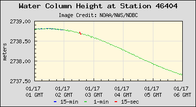
As of 0231:30, the initial water column height is 2738.80 Meters deep (8985.56 feet). Two minutes and thirty seconds later, that same water column height had dropped to 2738.66 Meters deep (8985.10 feet). Where did the four inches of water disappear to? Answer: The earth sunk; and continued to sink for the next several HOURS. As you can see from the second chart above, from 0230 GMT to 0600 GMT, the ocean continued to sink to 2737.7 meters deep (8981.95 feet). The buoy is too far away from shore to be affected by high/low tide, sowhere did the four feet of ocean water disappear to?
This means a Tectonic Plate in the Ocean named the “Juan de Fuca Plate” has made a sudden, eastward movement and slipped beneath another Tectonic Plate named the “North American Plate.” This type of event is usually followed by a massive upward movement of the North American Plate causing a very severe earthquake.
Here’s a map of the relevant Tectonic Plates: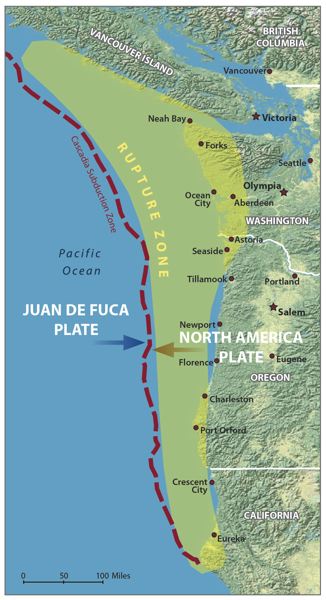
In the year 1700, a similar movement of plates is believed to have been the cause of a Magnitude 9.0 earthquake, which devastated the west coast of north America, and generated an ocean Tsunami that washed inland upwards of ten MILES!
FOUR MEAGER FEET OF WATER?
Lest you think that four feet of ocean depth is nothing to be concerned about, be reminded that the entire column of water . . . all 8985 feet of it . . . is what dropped four feet. And it did so over an area several miles wide!
When the tectonic plate snaps back upward, it can launch that entire 8985 foot column of water upward and toward the shore!
As the continental shelf rises toward the shore (the ocean gets more shallow) that 8985 foot column of water starts accumulating upon itself as it moves toward shore, becoming one massive wave, perhaps 45-50 feet tall, that hits the shore for twenty minutes!
Now do you see why this is a big deal?
If such a thing were to happen today, hundreds-of-thousands of people would be killed as a fifteen meter (45 foot) wall of water came ashore well inland passing Interstate 5 and destroying everything its path from the beach to Interstate 5.
Here is a map of I-5, everything to the left of it (to the west) would be wiped out: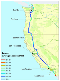
Mount Hood Volcano Can Be Triggered to Erupt
This type of Tectonic Movement has a direct effect upon the volcanos in the Cascadia Volcanic Chain, in particular, Mount Hood.
When the Juan de Fuca tectonic plate goes beneath the North American plate, it begins to get crushed. The heat from the friction of the two massive plates rubbing together, melts the Juan de Fuca plate into Magma (lava).
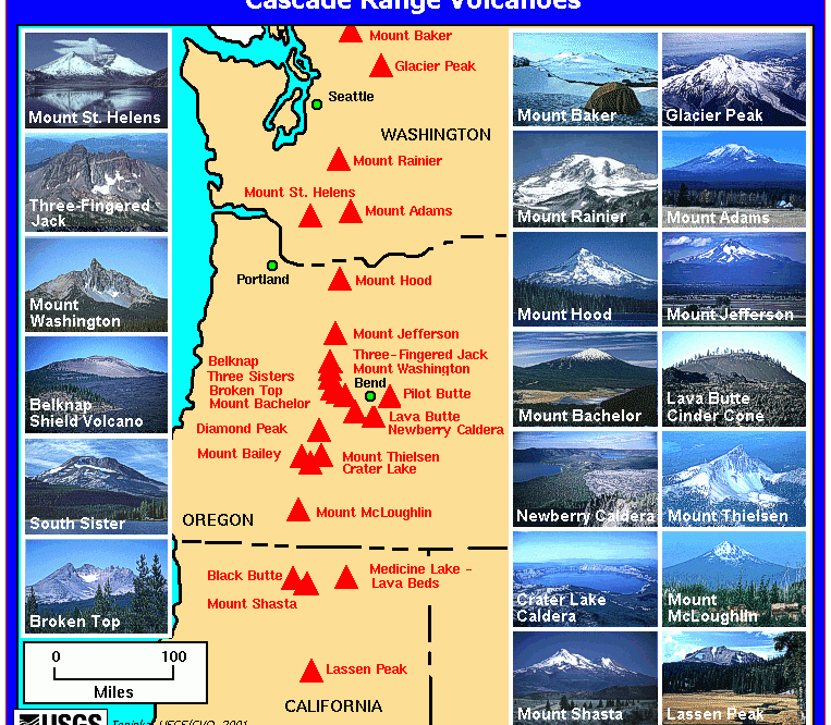
Directly next to the Cascadia Subduction Zone is the Mount Hood Volcano. Here’s a graphic to show you the relevant details:
 All along the Cascadia Subduction Zone are volcanoes. Most of them are inactive, but some are quite active. Here is a map of the volcanoes in the Cascade Mountains Range, so you have an understanding of the pressure relief valves (volcanoes) created over millions of years by these two tectonic plates scraping together. Mount Hood is to the right (east of) Portland, Oregon . . .
There is a magma tunnel leading directly from the Cascadia Subduction Zone straight up into Mount Hood! As the Juan de Fuca tectonic plate is being crushed (right now) it is melting into magma (lava). Whether or not there is enough magma to cause Mount Hood to erupt is unknown.
There has merely been an “event” in the Pacific Ocean off the coast of Oregon in the Cascadia Subduction Zone. This is a very rare occurrence with serious implications. It is worthy of very close monitoring by persons in the potentially-affected areas. This event is a potential warning of a POSSIBLE pending large earthquake on the west coast. There could also be an eruption at Mount Hood.
Folks in Washington, Oregon and northern California as well as in Vancouver, British Columbia, CANADA, should make certain they are prepared to take emergency action in the event a major quake does strike.
Full Historic Background and Detailed Explanation – Scary Stuff
Most people in the United States know just one fault line by name: the San Andreas, which runs nearly the length of California and is perpetually rumored to be on the verge of unleashing “the big one.” That rumor is misleading, no matter what the San Andreas ever does. Every fault line has an upper limit to its potency, determined by its length and width, and by how far it can slip. For the San Andreas, one of the most extensively studied and best understood fault lines in the world, that upper limit is roughly an 8.2—a powerful earthquake, but, because the Richter scale is logarithmic, only six per cent as strong as the 2011 event in Japan.
Just north of the San Andreas, however, lies another fault line. Known as the Cascadia subduction zone, it runs for seven hundred miles off the coast of the Pacific Northwest, beginning near Cape Mendocino, California, continuing along Oregon and Washington, and terminating around Vancouver Island, Canada. The “Cascadia” part of its name comes from the Cascade Range, a chain of volcanic mountains that follow the same course a hundred or so miles inland. The “subduction zone” part refers to a region of the planet where one tectonic plate is sliding underneath (subducting) another. Tectonic plates are those slabs of mantle and crust that, in their epochs-long drift, rearrange the earth’s continents and oceans. Most of the time, their movement is slow, harmless, and all but undetectable. Occasionally, at the borders where they meet, it is not.
Take your hands and hold them palms down, middle fingertips touching. Your right hand represents the North American tectonic plate, which bears on its back, among other things, our entire continent, from One World Trade Center to the Space Needle, in Seattle. Your left hand represents an oceanic plate called Juan de Fuca, ninety thousand square miles in size. The place where they meet is the Cascadia subduction zone. Now slide your left hand under your right one. That is what the Juan de Fuca plate is doing: slipping steadily beneath North America. When you try it, your right hand will slide up your left arm, as if you were pushing up your sleeve. That is what North America is not doing. It is stuck, wedged tight against the surface of the other plate.
Without moving your hands, curl your right knuckles up, so that they point toward the ceiling. Under pressure from Juan de Fuca, the stuck edge of North America is bulging upward and compressing eastward, at the rate of, respectively, three to four millimeters and thirty to forty millimeters a year. It can do so for quite some time, because, as continent stuff goes, it is young, made of rock that is still relatively elastic. (Rocks, like us, get stiffer as they age.) But it cannot do so indefinitely. There is a backstop—the craton, that ancient unbudgeable mass at the center of the continent—and, sooner or later, North America will rebound like a spring. If, on that occasion, only the southern part of the Cascadia subduction zone gives way—your first two fingers, say—the magnitude of the resulting quake will be somewhere between 8.0 and 8.6.That’sthe big one. If the entire zone gives way at once, an event that seismologists call a full-margin rupture, the magnitude will be somewhere between 8.7 and 9.2. That’s the very big one.
Flick your right fingers outward, forcefully, so that your hand flattens back down again. When the next very big earthquake hits, the northwest edge of the continent, from California to Canada and the continental shelf to the Cascades, will drop by as much as six feet and rebound thirty to a hundred feet to the west—losing, within minutes, all the elevation and compression it has gained over centuries. Some of that shift will take place beneath the ocean, displacing a colossal quantity of seawater. (Watch what your fingertips do when you flatten your hand.) The water will surge upward into a huge hill, then promptly collapse. One side will rush west, toward Japan. The other side will rush east, in a seven-hundred-mile liquid wall that will reach the Northwest coast, on average, fifteen minutes after the earthquake begins. By the time the shaking has ceased and the tsunami has receded, the region will be unrecognizable. Kenneth Murphy, who directs FEMA’s Region X, the division responsible for Oregon, Washington, Idaho, and Alaska, says, “Our operating assumption is that everything west of Interstate 5 will be toast.”
*********
TLB recommends EveningCompass for more hard-hitting stories.


Obama wants this to occur before the Nov election.